⛳ High Level, Ab is situated in or near the boreal moist forest biome.
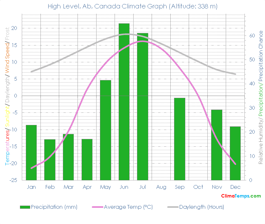
🌡️ The mean temperature is -1.5 degrees Celsius (29.3 degrees Fahrenheit). See the temperatures page for a monthly breakdown and the fixed scale graph.
☔ Total annual precipitation averages 329.2 mm (13 inches) which is equivalent to.
Simply paste the following HTML code into your webpage. Please include a link back to this website. There is one in the following code already. Edit the width attribute to change the size of the graph if needed:
✨ The longest day of the year is 18:02 long on the 22 of June and the shortest day is 5:57 long on the 21 of December.
🐇Were you to burrow down through the centre of the Earth from High Level, Ab you would pop up nearest to the climate station at Port-Aux-Francais, kerguelen islands, French Southern Lands where you would find a Tundra climate (Boreal rain forest biome).
🌍High Level, Ab, Canada is at 58°37'N, 117°9'W, 338 m (1109 ft). Check the location on the map.
| Climate Variable | Jan | Feb | Mar | Apr | May | Jun | Jul | Aug | Sep | Oct | Nov | Dec | Annual | ||
|---|---|---|---|---|---|---|---|---|---|---|---|---|---|---|---|
| Average Temperature °C ( °F) | -21 (-7) | -18 (0) | -10 (13) | 2 (35) | 10 (49) | 14 (58) | 16 (61) | 14 (57) | 8 (47) | - | -13 (9) | -20 (-4) | - | ||
| Average Precipitation mm (in) | 23 (1) | 17 (1) | 19 (1) | 17 (1) | 42 (2) | 65 (3) | 61 (2) | - | 34 (1) | - | 29 (1) | 22 (1) | - | ||
| Average Daylight Hours/ Day | 7h 10' | 9h 16' | 11h 48' | 14h 28' | 16h 52' | 18h 15' | 17h 37' | 15h 27' | 12h 50' | 10h 10' | 7h 46' | 6h 27' | 12h 00' | ||
| Sun altitude at solar noon on the 21st day (°). | 11.6 | 21 | 31.8 | 43.4 | 51.7 | 54.8 | 51.7 | 43.3 | 31.9 | 20.5 | 11.4 | 8.1 | 31.7 |
Please take a moment to share a climate graph or simply the address:
Thank You, so much! ❤️